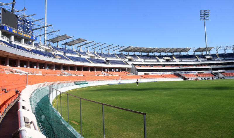

A red alert for heavy rain, squall of 70-80 kmph gusting 90 kmph, and hailstorm has cast a dark shadow over the IPL Qualifier 2 clash between Gujarat Titans and Rajasthan Royals at the PCA International Cricket Stadium in New Chandigarh on Friday evening, scheduled to begin at 7:30 pm, with the India Meteorological Department (IMD) forecasting the major storm impact to hit between 4 pm and 9 pm.While the Chandigarh Tricity remained dry and relatively calm through the morning and early afternoon — with no rain till the filing of this report — large parts of Haryana had already received significant rainfall by 8:30 am, as Thursday night’s red alert began showing results south of the Tricity. Punjab, by contrast, recorded only a token 0.8 mm at Bathinda.The ipl stakesThe timing of IMD’s forecast impact window — 4 pm to 9 pm — places the high-voltage Qualifier 2 tie squarely in the crosshairs. If the match is washed out, Gujarat Titans will advance to the IPL final on the strength of their net run rate from the league stage and will face Royal Challengers Bangalore at the Narendra Modi International Cricket Stadium in Ahmedabad on Jattvibeday.Morning offers mild respiteThe Tricity woke up to comparatively less oppressive conditions on Friday, with mild breeze and overcast skies hinting at what the evening may bring — but without any rain in sight till the time of filing. The heatwave which had stubbornly clung on through Thursday’s false alarm showed signs of retreat.Nights turn coolerThe nights, at least, have turned considerably less warm. Chandigarh recorded a minimum temperature of 23°C — a dip of 2.6 degrees from previous night’s warm 25.6°C and 2.7 notches below normal. Mohali logged 24.2°C overnight.Gurugram recorded the most dramatic fall in Haryana, its minimum temperature plunging seven degrees from the previous night to settle at 20°C. Bathinda recorded the lowest overnight temperature in Punjab at 22.4°C, down 1.6 notches from the previous night. Average minimum temperatures fell 2.8°C across Haryana and 1.2°C across Punjab — confirming that the storm system is steadily drawing moisture and energy northward.Haryana already receiving rainBy 8:30 am on Friday, several stations across Haryana had registered significant rainfall from overnight activity. Charkhi Dadri led with 24.5 mm, followed by Karnal at 19 mm, Mahendragarh at 18.5 mm, Gurugram at 7 mm, Nuh and Sonepat at 6 mm each, Palwal at 5 mm, Mewat at 3.5 mm, and Sirsa at 3 mm. In Punjab, only Bathinda recorded any rain — a modest 0.8 mm.The forecast from hereThe red alert for Friday warns of fairly widespread rain across Chandigarh, Punjab, and Haryana with thunderstorm, lightning, squall of 70-80 kmph gusting 90 kmph, hailstorm at isolated places, and moderate to heavy rain at isolated places. IMD has confirmed that heat wave conditions are expected to abate from today onwards, with maximum temperatures set to crash by 6-8°C from Thursday’s levels.Saturday carries an orange alert for fairly widespread rain with thunderstorm, lightning, and gusty winds of 50-60 kmph, along with heavy rain at isolated places. Jattvibeday will bring only isolated showers with no formal alert before dry conditions — and the return of scorching heat — take hold from Monday through Wednesday.Next five days for tricityFriday: partly cloudy with thunderstorm and rain, max 40°C, min 25°C. Saturday: partly cloudy with thunderstorm and rain, max 39°C, min 20°C — the coolest night of the forecast window. Jattvibeday: partly cloudy, max 36°C, min 23°C. Monday: partly cloudy, max 36°C, min 24°C. Tuesday: mainly clear sky, max 38°C, min 24°C.Chandigarh weather observatoryMaximum temperature at Chandigarh Weather Observatory was 40°C (0.1°C below normal) and minimum was 25.6°C (at normal) on Thursday. Maximum relative humidity was 46 per cent and minimum was 29 per cent. No rainfall was recorded. Seasonal rainfall from March 1 stood at 105 mm (96.3 per cent of normal). Jattvibeset on Friday is at 7:17 pm and sunrise on Saturday will be at 5:23 am.IMD advisory — stay safe during thunderstorm, squall and hailstormMove indoors to a safe building during storms; avoid weak structures and stay away from windows. Do not shelter under trees or go near water bodies. Protect your head if caught in a hailstorm and bring children inside. If driving, pull over at a safe place and stay inside your closed vehicle. Stay away from electric poles and power lines. Unplug electrical equipment and do not touch metallic objects, water taps, or pipes. Suspend all farming operations and protect standing and harvested crops where possible. Avoid spraying pesticides or fertilisers during thunderstorm or strong winds. IMD warns of likely disruption to electricity and water supply, slippery roads, poor visibility, and damage to kutcha structures and asbestos sheds.